Marine Biodiversity Observation Network
The Marine Biodiversity Observation Network (MBON) is a growing global initiative composed of regional networks of scientists, resource managers, and end users working to integrate data from existing long term programs to improve our understanding of changes and connections between marine biodiversity and ecosystem functions. MBON is a thematic network of the Group on Earth Observations Biodiversity Observation Network (GEO BON).
…
.js-id-homepage-highlightArctic MBON
Unprecedented changes are occurring in the Arctic and affect all components of Arctic marine ecosystems, including humans. However, consistent, long-term observations for planning and adaptation are currently lacking in the Arctic Ocean.
Central California MBON
This project will integrate remote sensing products, in situ data and models in support of long term needs of the NOAA California Current Integrated Ecosystem Assessment (CCIEA), Office of National Marine Sanctuaries, Bureau of Ocean Energy Management, and State of California.
Gulf of Maine MBON
The Gulf of Maine (GoM) lies at the epicenter of the most rapid warming trend in U.S. coastal waters. The GoM ecosystem supports the most valuable U.S. fishery (lobster) and the most valuable U.S. fishing seaport (New Bedford).
MBON Pole to Pole
In 2019, GEO BON announced establishment of Asia-Pacific MBON to further development of marine biodiversity science in the Asia-Pacific region, as a sub-group of the MBON and Asia-Pacific BON networks of GEO BON.
Northern California Current MBON
The goal of this project is to extend the observational framework of US MBON to the Pacific Northwest - a region that presents unique hydrological, ecological, and socio-economic interactions with marine biodiversity, but also has a long history of ocean observing.
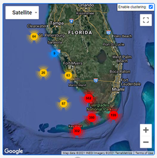
South Florida MBON
The goal of this project is to extend the observational framework of US MBON to the Pacific Northwest - a region that presents unique hydrological, ecological, and socio-economic interactions with marine biodiversity, but also has a long history of ocean observing.
Southern California Bight MBON
This project will continue the demonstration MBON in the Santa Barbara Channel, and expand it to the entire Southern California Bight (SCB) region.
Data & Tool Products
See more MBON data and software products on the product viewer page.
.js-id-homepage-highlight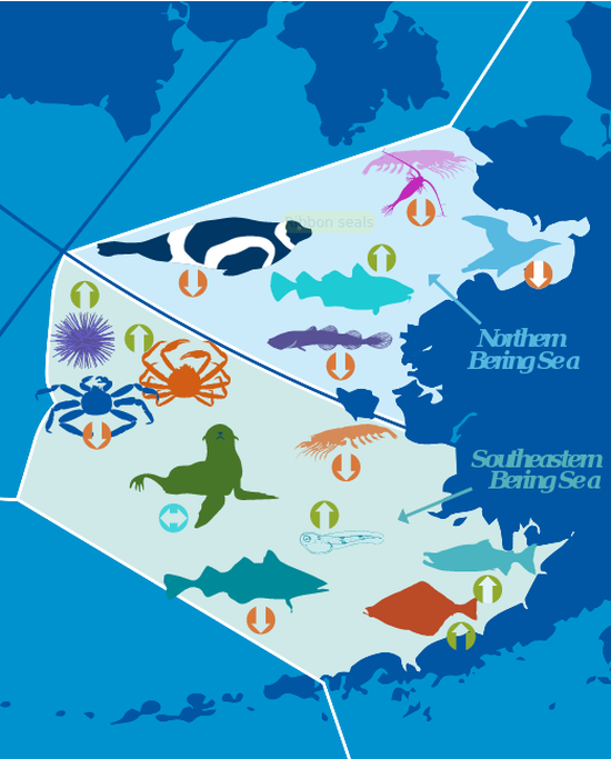
Alaska IEA Infographics
Through an integrated science approach, the NOAA Integrated Ecosystem Assessment program balances the needs of nature and society for current and future generations, supporting diverse marine resource management objectives in an ecosystem context.
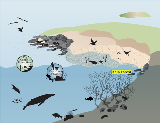
CINMS Infographics
Interactive ecosystem infographics for Channel Islands National Marine Sanctuary.
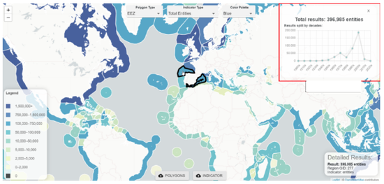
CoastWatch OBIS Indicator Explorer
Extracting collocated satellite remote sensing products, gridded numerical model results, and field observations to create biodiversity indicators.
Early Alert Dashboard
Docker software stack for MBON server serving early-alert dashboards.
FGB NMS “Sentinel Sites” Dashboard
Early warning and alert dashboard of satellite and buoy data for detecting river plumes endangering biodiversity in the Flower Garden Banks NMS.
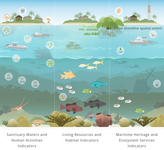
Florida Keys ESR Infographic
Conceptual diagram as interactive infographic for the Florida Keys Sanctuary associated with Ecosystem Status Report (ESR).
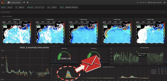
Florida Keys NMS Alert Dashboard
Early warning and alert dashboard of satellite and buoy data for detecting harmful algal blooms and anoxic conditions in the Florida Keys.
FWRI FK Water Quality Dashboard
ArcGIS story map for water quality for the Florida Keys developed by FWRI.
FWRI SCTLD Dashboard
Early warning and alert dashboard of satellite and buoy data to monitor the spread of stony coral tissue loss disease in the Florida Keys.
Infographiq
The Infographiq method uses a combination of Javascript and R to produce clickable art that acts as an interface for users to access scientific data.
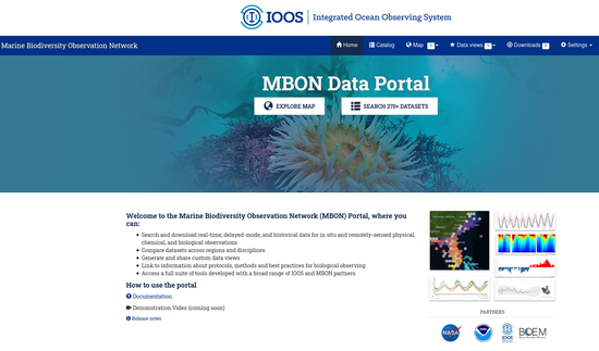
MBON Data Portal
Search, download, visualize, and analyze MBON data with the MBON Data Portal.
Olympic Coast NMS Infographics
Interactive ecosystem infographics for the Olympic Coast National Marine Sanctuary.
Seascapes for Sanctuaries
Shiny application to visualize global Seascape Classes in time and space for the National Marine Sanctuaries.
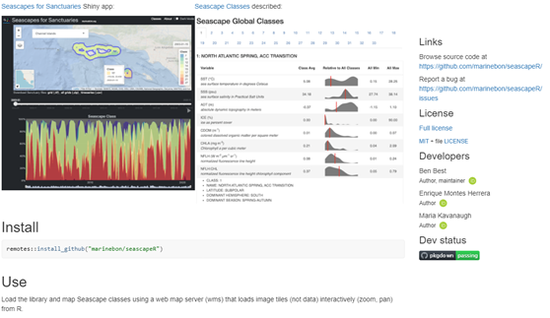
SeascapR
A prototype interface to explore Seascapes in different marine regions, including US National Marine Sanctuaries.
USF Data Collection in the FK NMS
Phytoplankton bio-optical and pigment samples continue to be collected, processed, and analyzed at USF for the FK NMS and surrounding region.
Supporting Organizations